

Map technology choice should depend mainly on familiarity with the technology and the budget available.
That sounds less glamorous than feature-by-feature comparisons, but in real Android projects it is usually the truth. Teams rarely fail because they picked the provider with the “wrong headline feature.” They fail because they underestimated the long-term cost of the stack they chose, or because they picked something the team could not move fast with. For me, the criteria that matter most in ongoing work are pricing, customization, and developer ergonomics. Other things — like licensing or policy fit — are still important, but they are usually early filtering criteria. They tend to eliminate options upfront. The real day-to-day engineering pain starts later: how expensive does this become as usage grows, how far can we push the product visually and functionally, and how painful is this stack to live with as Android developers. Google Maps SDK for Android is billed on a pay-as-you-go SKU model; Google’s Navigation SDK is billed separately per destination request; Mapbox’s Maps SDK is monthly active users (MAU)-based; OpenStreetMap data is open under ODbL but public OSM tile infrastructure is not a free production backend; and HERE positions its Android SDK as a broader location platform with different license tiers including Explore and Navigate.
Building map-heavy mobile products often requires more than SDK selection alone. Our custom software development team helps companies design scalable Android architectures that can evolve with product complexity over time.
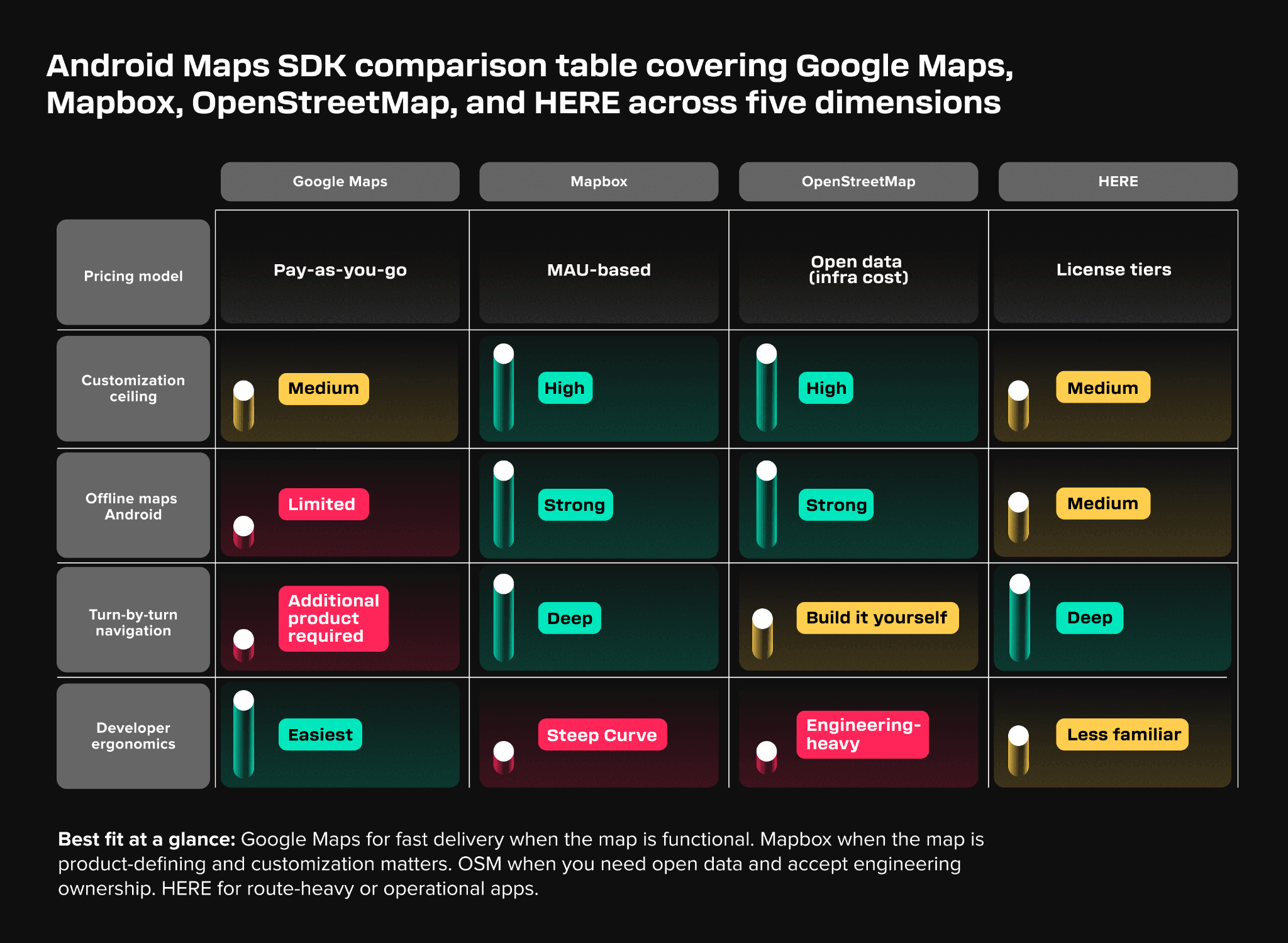
Google Maps: the easiest starting point, with real limits
I see Google Maps as easy to use and very common among Android developers. That still matters a lot. The onboarding path is familiar, the documentation is mature, and the Android ecosystem already knows how to work with it. Google Maps SDK for Android supports standard interactive maps, markers, camera controls, and map styling, and Google’s docs explicitly position it as a way to build dynamic, interactive, customized maps on Android. SDK itself is deeply documented around the standard Android integration model.
Where I think Google Maps becomes more constrained is when the map is no longer “a map in the app,” but part of the product identity. It does support customization, but in my view it is still harder to shape into a highly custom map product than style-first stacks. There are also practical policy boundaries that matter once the product becomes more advanced. Google’s policies are explicit that some things are exempt from caching restrictions — for example place IDs can be stored indefinitely — but the platform remains stricter than many teams expect around content storage and scraping.
So my view on Google Maps is still: it is a strong default when the team wants low friction and fast delivery. But once the product becomes deeply map-shaped, the comfort of familiarity can start competing with the need for control.
Mapbox: highly customizable, but you pay for that in complexity
I see Mapbox as highly customizable and as a solution with a steep learning curve.
Technically, Mapbox gives the team a much more explicit style-driven model. Its Android stack is built around sources, layers, camera behavior, and style definitions, and its offline model is a first-class concern rather than an afterthought — and for teams that need reliable offline maps on Android, this is one of Mapbox's clearest advantages over Google Maps SDK.. The Android offline docs describe downloading data for specific regions and zoom levels, and the implementation docs explicitly break offline data into style packs, tile regions, and tile storage concerns. Mapbox pricing is also structurally different from Google’s: the Maps SDK for Android is billed by MAU, and the Navigation SDK has its own pricing and product layer. Mapbox’s navigation docs also make it very clear that turn-by-turn is an internal “active guidance” state with route progress, route updates, off-route detection, and rerouting capabilities — in other words, it is not just “maps plus a few arrows.”
That is why Mapbox tends to appeal more when the map is not just functional, but product-defining. The tradeoff is exactly what I said earlier: the learning curve is real. You get flexibility, but you also inherit more concepts, more product surface, and more places where the architecture can become heavy if the team is not disciplined.
OpenStreetMap-based stacks: not just cheap, but open and engineering-heavy
I see OSM-based solutions as something to use if you do not have an initial budget, with the same steep learning curve, but highly customizable. I would keep that, but I would sharpen it.
The real advantage of OSM-based stacks is not just low initial cost. It is openness and control. OpenStreetMap data is licensed under ODbL by the OpenStreetMap Foundation, and the official copyright page explicitly allows copying, transmitting, adapting, and using the data as long as attribution and license obligations are respected. On Android, this usually means building with engines like MapLibre or libraries like osmDroid rather than consuming one single polished “OSM mobile SDK.” MapLibre’s style specification is JSON-based and explicitly defines sources, layers, zoom, center, pitch, and bearing, which is exactly why OSM-based solutions can be highly customizable.
But the part teams underestimate is that the cost does not disappear. It moves. The OpenStreetMap Foundation is very explicit that OSM data is free but the public tile servers are not a free high-scale delivery backend for third-party apps. The official tile usage policy says availability is best-effort, there is no SLA, and if your usage does not fit the policy you should use an alternative OSM-derived service or run your own stack. That is why I do not think “OSM is free” is the right framing. The better framing is: OSM can reduce licensing cost, but it often increases operational and architectural ownership.
So I would still say OSM-based solutions are a good option when budget is tight, but also when openness matters strategically. Just do not confuse “no big vendor bill on day one” with “lightweight engineering choice.”
HERE: less familiar to many Android teams, but stronger than it first looks
I was not personally coming into this with strong HERE experience, but I think it belongs in the comparison.
HERE Maps Android SDK is positioned around mapping, geocoding, routing, POIs, custom map styles, and camera controls. Its docs also make the product split unusually clear: you can choose the Explore license for a lighter starting point, or the Navigate license when you want feature-rich turn-by-turn navigation in the app. That is a useful distinction because it tells you where HERE expects to be strong: not just a generic map display, but a more complete location and navigation platform.
So if I had to place HERE in the comparison, I would say it is especially relevant for apps that are operational, route-heavy, or enterprise-like. It may not be the first SDK many Android developers reach for out of habit, but it is clearly built for use cases where routing and navigation depth matter more than broad developer familiarity.
Why I would avoid mixing providers
Mixing map providers sounds attractive, but in practice it is mostly never used as a stable end state because it multiplies pricing and generates development overhead. It can be viable during migration from one provider to another.
That is not just a business concern. It is also a technical one. Different providers bring different pricing units, different offline models, different routing behavior, different attribution rules, and different policy boundaries. Google’s Android policies are explicit about content restrictions and caching exceptions, and Google’s service-specific terms should not be treated as something you can ignore if you plan to combine providers loosely.
So in most cases I would rather extend one stack than combine multiple stacks for exactly the same reasons as above. Multiple providers almost always mean more SDK complexity, more QA combinations, and more product inconsistency. The one situation where mixing can make sense is migration, because temporary overlap can be less painful than a hard cutover. But I would still treat that as a transition strategy, not as a target architecture.
I would stick to one map solution during the life span of the project.
Turn-by-turn navigation is not “just another feature”
Turn-by-turn navigation is not just another map feature, because it can completely change how your app is perceived.
I think this is one of the biggest traps for mobile teams. Once you add real navigation, the app stops being judged as “an app with a map” and starts being judged as a navigation product. That changes everything. It changes user expectations, testing requirements, background behavior, product identity, and pricing. Google’s Navigation SDK is billed separately from the Maps SDK and is priced per destination request. Mapbox’s turn-by-turn docs describe an internal active-guidance model with route progress, rerouting, and dedicated UI components. HERE makes the same distinction through its Navigate license. All of that is a strong signal that navigation is not a cosmetic extension of map rendering. It is its own subsystem.
That is why I would never treat “we’ll add navigation later” as a minor roadmap item. In many products, that decision changes both the architecture and the business model around the map stack.
For teams building navigation-heavy mobile products, custom software development becomes critical once routing, offline support, real-time location handling, and long-term scalability enter the roadmap.
What AI brings to map products
AI in map-based apps means two distinct things that rarely belong in the same conversation: computer vision and geospatial localization on one side, large language models on the other. Conflating them leads to poor architectural decisions. They operate at different layers of the stack and solve different problems.
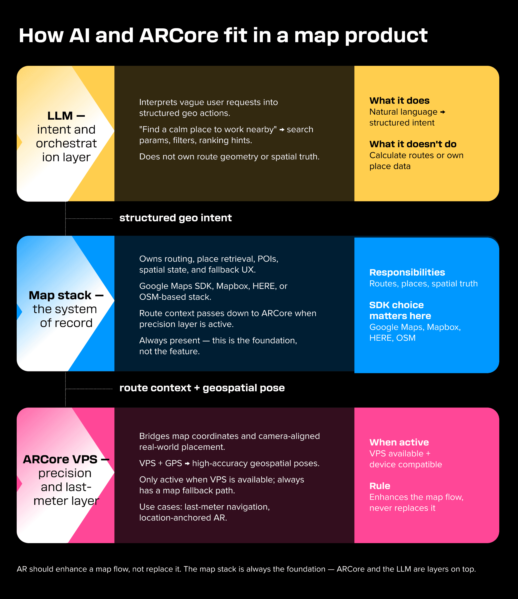
ARCore VPS is one kind of AI-assisted capability. It is effectively image-based localization and computer vision behind the curtain. The Geospatial API combines VPS and GPS data to generate high-accuracy geospatial poses, and Google explicitly says it can rely on VPS more heavily in indoor spaces and dense urban environments where GPS accuracy is poor. That is a very different kind of “AI” than what people usually mean when they talk about LLMs.
LLMs become useful one layer above that. They are not the right tool for route geometry, precise coordinates, or the source of truth for navigation state. They are useful for intent understanding. A user says something vague like “find a calm place nearby to work for an hour,” and the LLM translates that into structured geo actions: search preferences, ranking hints, filter constraints, maybe a suggested route sequence. Google already pushed Maps in that direction with its generative AI discovery experiment, where Google said its large language models analyze Maps’ data about hundreds of millions of places plus community insights to suggest relevant places for nuanced requests.
So this is how I would frame AI in map products: let the LLM interpret the messy human request, but let deterministic geo systems own the actual routing, place retrieval, and spatial truth. That is where LLMs fit best — as an interaction and orchestration layer, not as the map engine itself.
There is also a less visible AI role that matters a lot at scale: trust and data quality. Google has published multiple examples of using AI and machine learning to detect suspicious business profile edits, fake reviews, abusive content patterns, and fraudulent contributions in Maps. That does not feel flashy from a product-demo perspective, but it is one of the most important forms of AI in map products because recommendations are only as good as the underlying place data.
Where ARCore actually helps in a map-based Android app
ARCore becomes genuinely useful when you need precise location recognition and anchor navigation.
That is why I think the most realistic use cases are still last-meter navigation and some forms of gaming. ARCore’s Geospatial API is the part that makes this meaningful. It gives you a way to bridge map coordinates and camera-aligned, real-world placement. Technically, that means enabling the ARCore API, using geospatial mode, checking whether VPS is available, and only then deciding whether it makes sense to expose the AR path to the user. Google’s docs explicitly recommend checking VPS availability before an AR session and even use “enable an Enter AR button only when VPS is available” as an example. Keep in mind that this technology is not available everywhere and quality depends on the amount of data available in Google Street View coverage.
That is also why I would consider Geospatial API as auxiliary. I would not start with AR first. I would treat AR as a layer on top of a solid map stack. The map still owns route context, POIs, state, and fallback UX. ARCore becomes the precision layer that makes the last part of the experience more grounded when the device, environment, and location quality are good enough.
The real technical trap with ARCore
The technical trap with ARCore is not only that it is part of Google’s ecosystem. The bigger trap is cumbersome user experience if AR becomes the only path.
There should always be a backup plan. ARCore should not have sole responsibility for completing a feature. If the feature matters, the user should still be able to finish the task through a simpler path — normal map view, route preview, segment guidance, or some other non-AR flow. Architecturally, I think that makes more sense anyway, because ARCore Geospatial depends on things that can fail in perfectly normal usage: VPS availability, network conditions, heading quality, device support, and session readiness. Google’s own Geospatial docs frame VPS availability as something to check ahead of time specifically so the app can decide whether to expose the AR experience at all.
So my position is straightforward: AR should enhance a map flow, not replace it.
A concrete example from what we built
At Star, this mattered in a micro-mobility project where we combined Mapbox and ARCore VPS. The goal was not full turn-by-turn navigation yet, but rather custom segment navigation from A to B — basically a precursor to turn-by-turn. The map stack owned the route and spatial context. ARCore VPS was there to improve the precision layer when the experience needed better real-world alignment.
What I know from building something like that is that stretching an existing technical solution very quickly becomes a burden if the architecture is not shaped for where the product is heading. Building on top of the current stack always feels cheaper in the short term. At some point it stops being extension work and starts becoming structural debt.
That is the moment when teams should consider a revamp, communicate it beforehand, and explicitly create time and space for it during planning instead of pretending the current foundation can absorb infinite product growth.
The most expensive mistake a mobile team makes with maps
If I had to name one, I would say this:
The most expensive mistake a mobile team makes with maps is treating the map stack as a replaceable UI component instead of a product platform decision.
That mistake is cheap at MVP stage and expensive later. Teams often start with a familiar SDK because they only need a marker, a camera move, and maybe some directions. Then the product grows and suddenly needs deeper styling, offline behavior, a navigation layer, or better last-meter guidance. At that point, the original decision is no longer a UI convenience. It starts affecting pricing, offline architecture, routing integration, and feature velocity. Google separates map rendering and navigation into different products and billing models. Mapbox does the same. OSM-based stacks can save licensing cost, but they move more responsibility to your own infrastructure and operations. That is why the expensive mistake is usually not “choosing the wrong map SDK.” It is realizing too late that the map was central to the product all along.
Conclusion
How should your mobile team approach an Android map SDK comparison? The right starting point is not the feature list — it is the product trajectory. Think, where is the map in six months, and which stack can absorb that growth without becoming structural debt? To address this and if the team wants the easiest start and the map is not the product itself, Google Maps is still the most natural default.
For teams weighing Google Maps vs Mapbox on Android, the answer comes down to how central the map is to the product. If it is a major part of the product and heavy customization matters, Mapbox becomes much more attractive.
If there is no initial budget for licensing, or if openness and control matter strategically, OSM-based stacks are valid — but only if the team accepts the engineering ownership that comes with them.
If the product is strongly route-heavy or navigation-oriented, HERE deserves more attention than many Android teams usually give it.And on the AR/AI side, I would keep the split clear. ARCore VPS is closer to computer vision and geospatial localization. LLMs are more useful at the intent layer. They are not replacing the core map stack. They would make the map stack more usable, more precise, and more human-friendly when the product truly benefits from that.
Building a map-based Android product?
Map and location technology decisions have a way of looking straightforward early and becoming structurally significant later. The SDK that gets you to MVP fastest is not always the one that supports where the product needs to go.
At Star, we have built map-based Android products across mobility, navigation, and location-heavy enterprise applications — including work that combines custom routing, Mapbox, and ARCore VPS in production. We know where the architectural traps are and how to structure a map stack that does not become debt as the product grows.If you are choosing a map SDK, scoping a navigation layer, or thinking about how AR or AI fits into a location product, our custom software development team is worth speaking to.
FAQs
It depends on two things above all else: budget and how central the map is to your product. Google Maps is the lowest-friction starting point for most Android teams and is well-suited to apps where the map is functional rather than product-defining. Mapbox is the stronger choice when you need deep visual customization, a robust offline model, or full turn-by-turn navigation with architectural control. OSM-based stacks make sense when licensing cost matters strategically or when you need full data ownership — but they trade vendor cost for engineering ownership. HERE is worth serious consideration for route-heavy or operational apps where navigation depth matters more than broad developer familiarity.